Transit
This page was edited in 2002 to combine earlier writings and new material.
Transportation consists of all the modes of moving both people and goods
for all different purposes.
Distribution of goods (e.g. package delivery) is covered on its own
[PAGE].
Transit == Transportation of People.
This page is about the transportation of people and their
stuff
for work and play.
Granting that we can't banish automobiles, can we at least build a transportation system to take us farther and faster than we are used to thinking?
Imagine
- A system where you could use a personal or business
global address
to go to that destination,
- A system that would allow you intuitively or logically find your way to any part of the world,
- A system where the transportation landscape would match the local
geo-cultural landscape.
Basis
The system consists of interchanges and lines.
People arrive at an interchange and take a line to some other interchange:
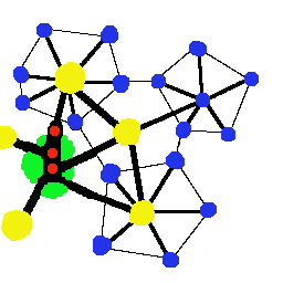
Transportation Web
(A better diagram is needed!)
|
- Cosmo - going UP one level, from a town center to a city center,
from a community center to a town center, etc. [Cosmo - for lack of a better word.]
- Local - going DOWN one level, closer to home,
from a town center to a community center,
from a community center to a neighborhood center, etc.
- Lateral - staying on SAME level, going from one town center to another,
from one village center to another, etc.
|
The principle would be the same regardless of the scale.
Conveyances wouldn't necessarily just shuttle between two interchanges;
they may well travel through several interchanges of the same or different
levels. They may make a loop around the city, a neighborhood, village, etc.
The important thing is the topology of the transit web.
You would get to your destination
by following the attraction to it
from one node (interchange) to another.
Transfers occur at interchanges as needed.
The dynamics of such a system is a research topic, below.
Modes
| Mode
| Definition, Examples
|
| (shoes? Wheelchairs)
| Walkways allow people to move about freely...
|
| Bicycle/Segway
| Two or three-wheeled human-powered or power-assisted vehicle.
|
| NEV
| Neighborhood Electric Vehicle. short range fully electric vehicle.
|
| Car
| (automobile) Good for rural travel, ..., small cities, towns.
Used under restriction in large cities. Hybrid gas-electric.
|
| Jitney
| A van with driver.
No Bike rack, but places for luggage and packages.
Operates in neighborhood, not inter-community.
[Issues such as collective liability insurance and bonding.]
Jitneys would be restricted to specific community route with optional stops via call-a-ride. (?)
|
| Taxi
| Privately-operated taxis range anywhere they do now.
|
| Small shuttle bus
| Approx 10-20 passengers with driver.
|
| Large shuttle bus
| 40 passengers with driver, but on a relaxed schedule
with 5-10 stops between points.
|
| Fast express shuttle
| (rail or bus) 40-60 passengers with driver.
No intermediate stops between endpoints.
|
| Commuter Rail
| Can run between urban towns (aka edge cities, suburbs) or from a rural town into an urban town.
|
| MagLev
| Magnetic Levitation train.
|
| et cetera
| Other modes of transportation - jet airplanes, safe small aircraft, ferries, slow boats to China, people movers, light rail, internet, ...
|
Levels vs Modes
See the
New World Model
for definitions of these levels.
| Level | Mode |
|---|
| between cities |
air, high speed rail, MagLev, bus, car, bike, ... |
| between towns |
=fast= express shuttle, Light Rail, car, bike, ... |
| between communities |
Bus Rapid Transit, Light Rail, car, NEV, bike, ... |
| between villages |
small shuttle bus, Street Car, bike, walkways, NEV, Segway, ... |
| between neighborhoods |
jitney, bicycle, walkways, NEV, Segway |
The above implies that:
- bike paths exist between cities and towns, and between rural towns and communities
- all transport is accessible so that wheelchairs have nearly the
same mobility as pedestrians
- and so on.
Downtown is just one of many towns making up the city.
Downtowns consist of communities of villages of neighborhoods just like
any other town, so there is need for mobility within downtown itself, such as via street car or circulating buses. See biblio for an example of such a system.
Transfers and Interchanges
Transfers are made at interchanges —
intermodal transfer centers,
hubs, nodes, stops, ports, stations,
plazas, ...
These places must be sheltered from weather,
they must be comfortable, clean, safe, and interesting.
Hubs will typically be at or near activity centers, such as
a village square, espresso bar, newsstand, regional mall, etc.
Information of the simplest kind — like the next time each shuttle is
projected to arrive (depart) from the node should be displayed.
This way, you can relax, go to a shop of interest or need, whatever.
Knowing your wait time would make your travel more pleasant.
This is possible via geo-locators on all shuttles, with
arrival times being distributed to hubs. The neighborhood level hub could have a cellular device that would have a simple (one line?) LCD display.
See
Transit Tracker
provided by TriMet in Portland, Oregon.
Main lines could originate in a village, go to their
community center, then perhaps through another community on the way to a town stop.
Some might even continue to downtown before returning to the end of the line.
In this way, many riders could stay on board for an entire trip - no transfer needed.
However, coverage for the whole area is via transfers.
Conventional wisdom tells us to avoid transfers at all costs.
Conventional systems attempt to schedule reasonable transfers where possible.
But since there is no overall system philosophy or design, transfers can not be
optimized - it's hopeless.
That is why transfer times are not consistent throughout the
system or the day.
Routes do not contribute to the system holistically.
In contrast, a system of meaningful transfers
could create synergy, waves of transportation energy, pulsating throughout
the region.
Back downtown for a last note on interchanges.
What could serve as an interchange be for a city?
You can't practically bring everyone to a single point or station downtown.
For a city the size of Portland,
consider a people mover to move people
north and south along the existing transit mall to reach transit
connections to outlying towns.
Large cities are interlaced with subways for this purpose,
the subways continuing on the surface connecting to surrounding cities and suburbs.
(See the note about downtown in at the end of the Levels and Modes section.)
Typical Trips
People need to
go to work,
go to school,
do errands,
enjoy recreational activities and cultural events, dine out, and so on.
Trips are taken for a single purpose -
go to work and back home;
go to school and back home;
go shopping and bring stuff home;
go out for dinner and come home stuffed.
These are common things to do.
Tours, or multi-purpose, multi-stop trips, are taken in the next section.
The trips below could be for any of the above purposes.
| A Trip | Possible Transportation |
|---|
| to an adjacent neighborhood
|
may be walkable, certainly bikeable. Use your car, or catch a short transit ride.
|
| to your village
|
could be made via neighborhood transit to your village, or by walking depending on your proximity to the village.
|
| to an neighborhood on the other side of your village
|
could be made via neighborhood transit to your village, then to the remote neighborhood. The same transit vehicle may connect, or you may have to switch to the other neighborhood's shuttle after a brief wait or errand in the village.
|
| to another village in your community
|
is started by taking transit into your village. From there, you might go directly to a neighboring village, or more likely, you'd go up to the community level and then to the desired village.
|
| to another community in your town
|
is started by taking transit into your community. From there, you might go directly to a neighboring community, or more likely, you'd go up to the town level and then to the desired community.
|
| to your town
|
is in the cosmo direction.
|
| to downtown
|
is no different than any other town. Downtown is not necessarily the center of the city. The airport and other transport would be major attractors, as
would be each town with cultural facilities, nightspots, etc.
|
| to a neighborhood in another part of the city
|
can be made by any combination of going up levels, staying on a level, and going down levels. What ever way you want to get there.
One can always go up to the highest level that contains the destination, then
descend on it.
Or one could traverse village and community lines to move about.
|
[Transit-Oriented Development,
or transit serving established neighborhoods.
Live within walking distance of one community center - work within walking distance from some other community in same town.
May have a direct community-to-community connection, or may have to ride
into nearest town to get to the work community.
Same shuttle may serve both communities, passing through the town
in its 'orbit'.
[Need a table showing number of transfers as function of (live,work).
Time/Distance covered by the modes.]
Tours
A tour is a multi-purpose trip.
You sometimes need to do a number of things
while you are out.
-
You may be able to do each thing independently,
in any order, at any time.
-
You may have to do one or more things
at particular times, e.g.
a lunch date, doctor's appointment, ...
-
You may have to visit some places in a particular order.
For example, you may need to pick something up at one place
or use it later in your tour,
then return it, or drop it off elsewhere.
An example of a most enjoyable tour goes here -- picking up some bakery and deli items for dinner on the way home after a day on the transportation web.
[Transpersonal Web allows you to go where you want to go, pivoting as needed from one place to another to complete a tour
.]
Taking Stuff with You
[Provisions for taking (luggage, baggage, suitcase, carry-on, purchases, food?) on board. Ethics of. Help with?]
[Bike or Segway on bus, max (light rail), amtrak.]
How is this any different than what we have now?
Today's
TriMet
lines are OK for someone making the same trip every day (once they get it figured out).
But a trip made at a different time of day may have weird timing
or an alternate route might be radically different from a familiar commute. A foray to a new place requires time to do route planning and time planning.
The proposed system is different in at least two ways:
-
Connectivity -
The TriMet system admittedly lacks connectivity between adjacent communities.
They are working on it, because
a good transit system must compliment the places it serves
in order to have good
connectivity
.
-
Faster connections within the urban area -
High speed links (not light rail or bus)
could take you farther, faster between stops in order tie places together.
Consider the following examples of how the current system differs
from this world transportation model.
-
Example #1: TriMet has some Cross-Town Buses that connect some transit centers or parts of town without going downtown.
(I Couldn't find any definition on TriMet's website.)
How Different:
These lines should connect town centers expeditiously, with a minimum of stops.
Metro's
2040 Plan calls for
new service to suburbs and connecting suburb to suburb
(TriMet's words).
But to be effective,
a bus should not stop 36 times when trying to connect regional or town centers!
This is why people prefer automobiles.
-
Example #2: TriMet #43 Runs from the downtown transit mall to Washington Square. Its route name is TAYLORS FERRY.
It runs south through Lair Hill, Corbett, then back up hill via Taylor's Ferry Road all the way out to Washington Square.
Very few ride it all the way from WASHSQ into town since there are more direct routes to take.
So what kind of route is this exactly?
A route that needs to cover Taylors Ferry and terminates at two major centers I guess.
People who live along TF use it to get downtown, slowly.
There are many of these kinds of routes in the TriMet system, that drag along arterials picking up and dropping off.
The riders just have to figure out how to piece them together to get where they are going.
How Different:
The proposed system would more likely service Lair Hill and Corbett as neighborhoods close to town and just shuttle between them - not go up
Taylor's Ferry Road.
The up/down hill link would be provided separately, perhaps as a shuttle link crossing the Willamette River connecting Burlingame easily to Sellwood.
There would be a major interchange where they all meet (Taylors Ferry, Sellwood Bridge, Corbett, Lake Oswego, etc).
It is an entirely different way of thinking about a transit system.
-
Example #3: Often times the #38 bus I take home from downtown is late because it has to fight its way
through congestion to get back into downtown to make another run.
Or the first leg of my trip is delayed, and I get downtown too
late to catch a #38 that is on time.
While I wait to catch the next #38, several other buses leave Downtown for my part of town.
They drop many people off before they get very far out of downtown.
How Different:
I would rather take any of a number of generic limited-stop buses
out to a point
where it could meet other buses that go further out to other places.
That would eliminate the need for my further-out bus
to come into downtown congestion, causing it
to be late.
It would also allow the further-out buses to run more frequently
on their shorter routes.
This design requires transfers, but I think it would minimize impact of inevitable delays by providing more frequency along main routes. It would also allow for fairly fine-grained tuning, and allow capacity to be added easily. People wouldn't mind if the buses started running every 5 minutes instead of every 7 on a main line, for example.
Riders would use a system of buses rather than having to depend on a particular
bus arriving at a particular time.
TriMet's Predicament
TriMet
is the tri-county transit operator for the Portland area.
Routes are not easily apparent on the system map.
The TriMet quadrants need wholesale re-vision.
Their on-line system maps zooms to rectangular chunks of square miles without regard for terrain or
recognition that Portland is divided severely by the Willamette River
the West Hills, and freeways - ie not useful subsets of the area.
A map based on a world model would zoom from city to town, from town to community, etc, along their natural and man-made boundaries.
(Same for all other cites in the world.)
TriMet experiments with a variety of services, and tweaks their system
map a little each year.
A comprehensive design approach should make a more efficient system, even if it has to be phased in or built over a decade --
If 'frequent bus' is attempting to emulate light rail service, then let's go ahead and design the system around it, and build up the capacity.
One particular future MAX line is planned for a right-away set aside
for it - along I-205, so bus lining is not possible there.
However,
I suspect this will not be done system wide prior to building
the other MAX lines,
because it would involve cutting direct bus routes in favor of feeder lines,
which would upset the ridership.
By waiting till a line is built,
TriMet has an ironclad excuse for changing affected bus routes.
This is the way it goes under the current planning scheme (in my opinion).
Please tell me if I am wrong about this.
Transit Union resistance to such plans?
Use retired drivers in the community and village routes,
working part time - mornings or evenings only,
or split shifts if they need the income.
Not exactly Hub and Spoke
Each place would have a interchange
and connections to neighboring places, but this does not imply
that the system is a simple hub and spoke system.
You could think of it as kind of a multi-level hub and spoke with more interconnections between like entities.
Hub and spoke systems have their own particular characteristics.
This system consists completely of various kinds shuttles or cycles operating between and within levels.
The lower levels of this system are not synchronized.
Above the community level, all system transfers are scheduled,
timed, tracked, and synchronized.
Below the community level, the two modes may get in/out of phase with each other. On this scale, it won't seem like lack of synchronization, since travel is from Leaf Nodes at the start or end of a trip, and usually near a market area of some kind.
There seems to be plenty of literature in regional science about
hub and spoke network models.
Automobiles
Private automobiles will use existing roadways of course, but some new
interconnecting routes may be available only for the transport web. I.E.,
some new right-of-way might be a
one-lane, alternating one-way shuttle line, plus bikelanes/sidewalk.
Consider a transit connection between
Milwaukie and Lake Oswego (crossing the Willamette River in Oregon) that does not provide for automobiles, only bus, bike and ped. I think Oswegons might even
like this because it wold not permit massive auto traffic from southeast to invade
their community.
Directional signage for auto drivers could take advantage of the standardized
name space in the new world model.
Research
I can think of at least the following research areas:
- Attempt to approximate a transit map for the Portland metro area.
- Develop a method for setting up a minimal spanning tree computation (of
some kind) given the desired nodes and available/potential links.
Use this as an initial feasible map.
- Extend the spanning tree to include connections to lateral nodes.
- Develop a Simulation/Model to calculate the frequency,
cycling, and timing needed to carry current loads.
Determine travel times from point to point,
number of transfers needed for various trips, and so on.
- Calculate the number and kind of each shuttle needed,
and the miles of
each kind of mode used to serve a given area.
(ie cost of operation based on ridership).
- Compare Coverage area vs Depth into areas. I.e. do you want to cover
the entire area, but only down to a certain level - or do you want to go deeper into some areas where ridership is greater? Develop a model.
- Develop a model for fares. Simplest might be based on time
within system regardless of mode.
- Develop a strategy for the placement of bus garages that minimize deadheading.
- Develop a strategy for 'dynamic scheduling' or whatever they call
keeping a queue of buses on standby to send out on fixed routes if the usual circulating bus is running behind, so as to keep the route on schedule.
Layered Systems
||
Bibliography
||
New World Model Home Page
||
dialectrix home